For the past several weeks, public attention in northern Bangladesh centred on one key indicator—the water level of the Teesta River at Dalia Point. Whenever the river exceeded the official danger level, flood alerts were issued. Once the water dropped below that mark, many believed the crisis had ended.
In reality, for thousands of residents living along the Teesta and Brahmaputra rivers, the most severe damage began only after the floodwaters receded.
During the final week of June, rising river levels inundated large areas of Rangpur, Kurigram, Lalmonirhat and Gaibandha, forcing many families to leave their homes. But as the water rapidly drained away, widespread riverbank erosion intensified, washing away houses, schools, roads and agricultural land. This recurring pattern has once again highlighted a major gap in Bangladesh's disaster management approach, which focuses more on emergency flood response than on reducing the long-term impacts of post-flood erosion.
Sudden Changes in River Levels Increase Erosion
Data from the Bangladesh Water Development Board (BWDB) show that the Teesta River experienced sharp fluctuations in water level during the last week of June.
On 23 June, the river rose one centimetre above the danger level at Dalia before dropping below it the next day. Heavy rainfall in upstream areas of India's West Bengal, combined with water released from the Gajoldoba Barrage, caused the river to rise again, reaching seven centimetres above the danger mark on 28 June.
The situation changed quickly once more. On 29 June, the river level fluctuated throughout the day before falling 30 centimetres below the danger level on 30 June. Within the following 12 hours, it dropped by another 13 centimetres.
Officials from the BWDB say these rapid rises and falls have become more frequent because of upstream rainfall and barrage operations. According to engineers, although rising water creates flooding, the sharp decline in water level afterwards often causes the most destructive riverbank erosion.
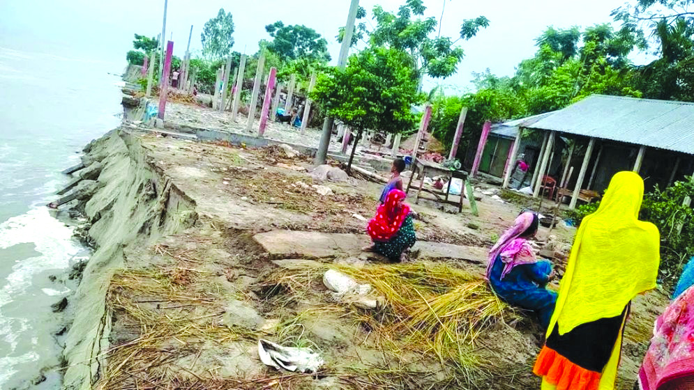
When Floodwaters Recede, Permanent Losses Begin
Flooding is the most visible stage of a river disaster. Images of submerged homes, damaged roads, closed schools and displaced families usually dominate public attention.
However, specialists warn that the most lasting destruction often occurs after the floodwaters begin to recede. As river levels fall rapidly, the water pressure that temporarily supports saturated riverbanks disappears. The weakened soil then becomes unstable, causing large sections of land to collapse into the river. This process, known as drawdown erosion, can destroy vast areas of land several days after floodwaters have withdrawn, leaving affected communities with permanent losses long after the immediate flood has ended.