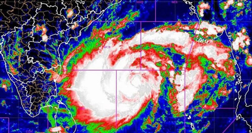
Very Severe Cyclonic Storm Mocha moved further towards Bangladesh between 12am and 4am on Saturday (13 May), said Meteorologist Mostofa Kamal Polash, a PhD researcher on meteorology and climate at the University of Saskatchewan in Canada.
The cyclone has inched closer to the coast of Khulna and Barisal divisions, according to his forecast.
"There is a 99% chance that the cyclone will pass through Saint Martins Island and Cox's Bazar between 7am and 3pm on 14 May (Sunday)," he said.
"At the time, its maximum sustained wind speed could be 185-200km per hour."
The meteorologist also warned, "Char areas Noakhali and Bhola may face the threat of 10-15 feet-high tides due to the impact of the cyclone."
According to a Met Office press release, the severe cyclonic storm Mocha has moved north-northeastwards at 15.1N latitude and 88.8E longitude.
On 12 May at midnight, the cyclone was 865km south-southwest from the Chattogram seaport, 795km south-southwest from the Cox's Bazar seaport, 830km south-southwest from the Mongla seaport and 795km south-southwest from the Payra seaport.
Meanwhile, the maritime ports of Chattogram, Cox's Bazar, and Payra have been advised to hoist great danger signal 8 as Cyclone Mocha intensified into a very severe cyclonic storm over the southeastern Bay of Bengal and its adjacent areas on Friday (12 May). Besides, Mongla seaport has been asked to show local warning signal 4.
Coastal districts of Cox's Bazar, Chattogram, Feni, Noakhali, Lakshmipur, Chandpur, Barishal, Bhola, Patuakhali, Jhalkathi, Pirojpur, Barguna, and their nearby islands and chars will also be under great danger signal 8.
In a bulletin released at 9pm Friday, the Bangladesh Meteorological Department has advised all fishing boats and trawlers in the northern Bay of Bengal to seek shelter immediately.
Md Monowar Hossain, meteorologist at the Met office, told The Business Standard that the impact of the cyclone may begin on Cox's Bazar and adjacent coastal areas from the evening of 13 May.
The maximum sustained wind speed could be 140km-160km per hour at the 74km area from the centre of the storm, he said.
Cyclone Mocha moves further towards Bangladesh